
Site Planning
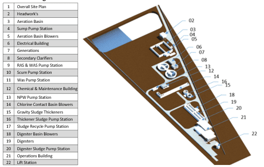
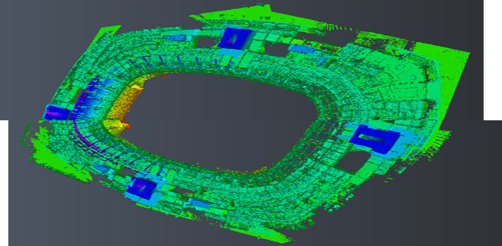
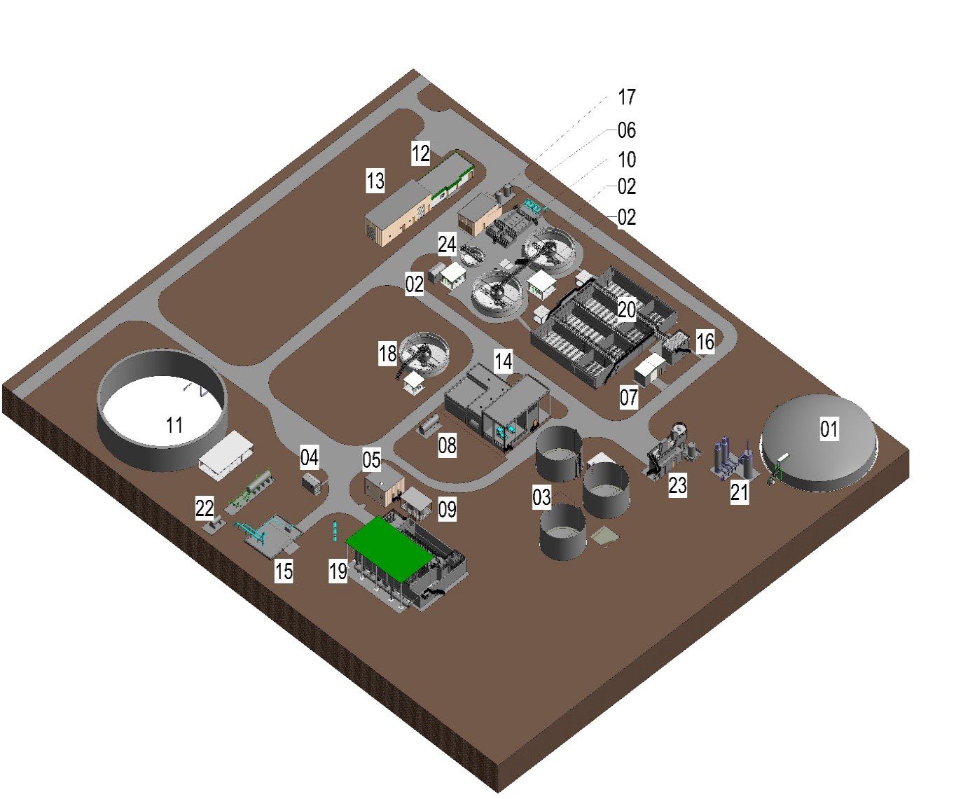
Building Information Modeling (BIM) services have revolutionized the role of surveyors in the construction and real estate industries. Surveyors are responsible for accurately measuring, mapping, and assessing land, properties, and construction sites. TAAL Tech’s BIM services offer a comprehensive set of tools and methodologies that empower surveyors to enhance their surveying processes, improve data accuracy, and provide valuable insights to project stakeholders. At the core of TAAL Tech’s BIM services for surveyors is the use of advanced technology, including BIM software, laser scanning, and geospatial information systems (GIS). These tools enable surveyors to create detailed 3D models and point cloud data of construction sites and existing structures. These digital representations encompass precise measurements, allowing for more accurate site documentation. TAAL Tech’s BIM services enhance surveyors’ capabilities by providing a holistic view of the site. Surveyors can integrate their survey data into the BIM model, creating a rich source of information for architects, engineers, contractors, and other project stakeholders. This integrated approach fosters collaboration and streamlines communication, ensuring that all parties work with the most up-to-date and accurate data. 3D laser scan to BIM conversion to By combining BIM with survey data, quantity take offs become more accurate and efficient. Survey companies can help estimate material quantities and project costs with greater precision, reducing the risk of under- or overestimation. BIM can be used to create detailed maps of underground and above-ground infrastructure, enhancing the quality of utility location and asset mapping services provided by survey companies. BIM models can be used to perform in-depth site analysis, helping survey companies identify potential challenges, such as drainage issues, soil conditions, or environmental constraints. This information is invaluable for project planning and design. Survey companies can use BIM to verify that construction aligns with the designed plans, ensuring the built environment accurately reflects the intended design. Laser Scan Input Site Planning Transparent, agile, flexible and well-aligned engagement approach Nurturing engineering partnerships for Dependable and reliable – delivering success on time, every time Well-established processes and frameworks to ensure 100% compliance High focus on talent acquisition, management and development Innovative solutions with cutting-edge technology and forward-thinking strategies
Engineering solutions for a better tomorrow
Services
3D Laser Scan to BIM and Data Integration
provide an accurate representation of the site’s topography and existing
conditions.
BIM for Quantity Take-off
Infrastructure Asset Mapping
BIM Site Analysis
Construction Verification
Samples
Why TAAL Tech?

Customer-centric

Commitment & Trust
15+ years

Proven Reputation

Quality Focus

Skilled Professionals

Future-ready
Get Started Now
Secure better project outcomes and improved ROI with TAAL Tech’s digitized engineering support. Get started now!